The Philippines is a Southeast Asian country in the Western Pacific, comprising more than 7,000 islands. Filipinos have always been aware of the natural wonders in our country, and that is why we’ve always been proud to show off to tourists how much more fun it is here. We’ve since added many more sights, crafted by hand and sweat, to showcase our culture.
- Boracay - Boracay is a small island in the central Philippines. It's known for its resorts and beaches. Along the west coast, White Beach is backed by palm trees, bars, and restaurants. On the east coast, strong winds make Bulabog Beach a hub for water sports. Nearby, the observation deck on Mount Luho offers panoramic views over the island. Offshore, coral reefs, and shipwrecks are home to diverse marine life
--------------------------------------------------------------------------------------------------------
- Puerto Princesa Underground River
The Puerto Princesa Subterranean River National Park is a protected area of the Philippines located about 80 kilometres (50 mi) north of the city centre of Puerto Princesa, Palawan. The river is also called Puerto Princesa Underground River. The national park is located in the Saint Paul Mountain Range on the western coast of the island. It is bordered by St. Paul Bay to the north and the Babuyan River to the east. The City Government of Puerto Princesa has managed the National Park since 1992. The entrance to the subterranean river is a short hike or boat ride from the town Sabang.
-------------------------------------------------------------------------------------------------
- El Nino Marine Reserve Park
El Nido (officially the Municipality of El Nido) is a first class municipality and managed resource protected area in the province of Palawan in the Philippines. It is about 420 kilometres (260 mi) south-west of Manila, and about 238 kilometres (148 mi) north-east of Puerto Princesa, Palawan’s capital. It is known for its white-sand beaches, coral reefs, limestone cliffs and as the gateway to the Bacuit archipelago.
--------------------------------------------------------------------------------------------------
- Coron Island Kayangan Lake
The area around the wrecks has rock formations which provide for snorkeling opportunities, with underwater visibility extending up to 80 feet (24 m). The water is often calm. Coron is one of the most visited destinations for wreck diving in the Philippines. Wreck dive sites are found in depths as shallow as 10–30 feet (3.0–9.1 m) and as deep as 120–140 feet (37–43 m). Most are in the range of about 60–80 feet (18–24 m).
Dive sites around Coron include many different reef dive sites and "Günter´s Cave", also known as Cathedral Cave because during a certain time of the day, the sun throws a beam of light through a hole in the cave ceiling, illuminating the inside. It is possible to surface in the cave, as the hole in the cave-ceiling allows fresh air to enter. The cave is named after Günther Bernert, who was part of the first dive group to explore the cave, after hearing from local fishermen about its existence.
-------------------------------------------------------------------------------------------------
- Bohol
Bohol is a province of the Philippines, in the country’s Central Visayas region. It comprises Bohol Island and numerous smaller surrounding islands. Bohol is known for coral reefs and unusual geological formations, notably the Chocolate Hills. On the main island, near the town of Carmen, these 1,200 or so symmetrical mounds turn cocoa-brown in the dry season, contrasting with the surrounding jungle's greenery.
------------------------------------------------------------------------------------------------
- Bantayan Island Cebu

-------------------------------------------------------------------------------------------------------
- Camotes Island
Camotes Islands is a group of islands in the Camotes Sea, Philippines. The island group is located east of Cebu Island, southwest of Leyte Island, and north of Bohol Island. It is 34 nautical miles (63 km; 39 mi) from Cebu City and is part of Cebu. According to the 2015 census, it has a population of 102,996.[1] Population has grown 20.3% since 1990, equivalent to an annual growth rate of 0.93%
-------------------------------------------------------------------------------------------
- Mactan,Cebu
Mactan or Maktan is a densely populated island located a few kilometres (1 mile) from Cebu Island in the Philippines. The island is part of Cebu Province and it is divided into Lapu-Lapu City and the municipality of Cordova. The island is separated from Cebu by the Mactan Channel which is crossed by two bridges: the Marcelo Fernan Bridge and the Mactan-Mandaue Bridge. The island covers some 65 square kilometres (25 sq mi) and is home to some 470,000 people, making it the nation's most densely populated island. Along with Olango Island Group, the isles are administered as 1 city and a municipality covering 75.25 square kilometres (29.05 sq mi).
------------------------------------------------------------------------------------------
- CEBU
Cebu is a 1st provincial income class island province of the Philippines located in the Central Visayas region, and consisting of the main island itself and 167 surrounding islands and islets. Cebu is one of the most developed provinces in the Philippines, with Cebu City as the main center of commerce, trade, education and industry in the Visayas. In a decade it has transformed into a global hub for shipping, furniture-making, tourism, business processing services, and heavy industry
------------------------------------------------------------------------------------------------
- Malapascua Island
----------------------------------------------------------------------------------------------------
- Siargao
----------------------------------------------------------------------------------------------
- Taal Lake
Taal Lake, formerly known as Bombón Lake, is a freshwater lake in the province of Batangas, on the island of Luzon in the Philippines. The lake fills Taal Caldera, a large volcanic caldera formed by very large eruptions between 500,000 and 100,000 years ago. It is the country's third largest lake after Laguna de Bay and Lake Lanao. Volcano Island, the location of Taal Volcano's historical eruptions and responsible for the lake's sulfuric content, lies near the center of the lake. There is a crater lake on Volcano Island. Known as the Yellow Lake or the Main Crater Lake, it contains its own small island, Vulcan Point. Vulcan Point was thought to be the largest third order island in the world but Treasure Island (Ontario) is much bigger and is thought to be the world largest, and is also on a freshwater lake.
--------------------------------------------------------------------------------------------
- Sumilon Island,Cebu
-------------------------------------------------------------------------------------------------
- Cebu, SINULOG FESTIVAL
The Sinulog-Santo Niño Festival is an annual cultural and religious festival held on the third Sunday of January in Cebu City, and is the centre of the Santo Niño Catholic celebrations in the Philippines.
The festival is considered to be one of the most popular festivals in the Philippines, with every celebration of the festival routinely attracting around 1 to 2 million people from all over the Philippines every year. Aside from the religious aspect of the festival, Sinulog is also famous for its street parties, usually happening the night before and the night of the main festival.
---------------------------------------------------------------------------------------------
- Baguio City
Baguio, on the Philippines’ Luzon island, is a mountain town of universities and resorts. Called the “City of Pines,” it’s particularly popular in summer due to unusually cooler weather. At its center is Burnham Park, with gardens and a lake. Nearby, Baguio Cathedral, completed in 1936, has a rose-hued exterior. The main thoroughfare is Session Road, lined with shops, restaurants and entertainment options.
---------------------------------------------------------------------------------------
- Tagaytay
Tagaytay is a popular holiday town south of Manila on the Philippine island Luzon. Known for its mild climate, it sits on a ridge above Taal Volcano Island, an active volcano surrounded by Taal Lake. Overlooking the area, People’s Park in the Sky occupies the grounds of a never-finished presidential mansion. Picnic Grove is a recreation area with trails and a zip line.
-----------------------------------------------------------------------------------------------
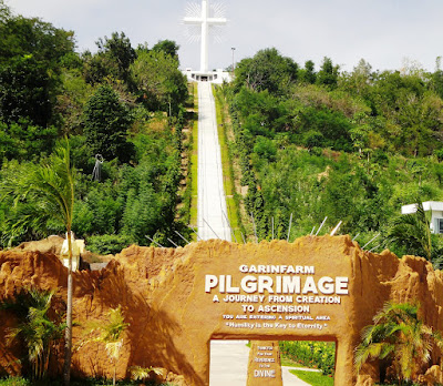
- Garin Farm Pilgrim, Iloilo
-----------------------------------------------------------------------------------------------------------------
- Camiguin Island
------------------------------------------------------------------------------------------------------------
- Batanes
-------------------------------------------------------------------------------------------
- Borawan Island, Padre Burgos, Quezon
-------------------------------------------------------------------------------------------------
- Negros
-------------------------------------------------------------------------------------------
- Gigantes Island
------------------------------------------------------------------------------------------------
- Vigan
------------------------------------------------------------------------------------------------------


Comments
Post a Comment